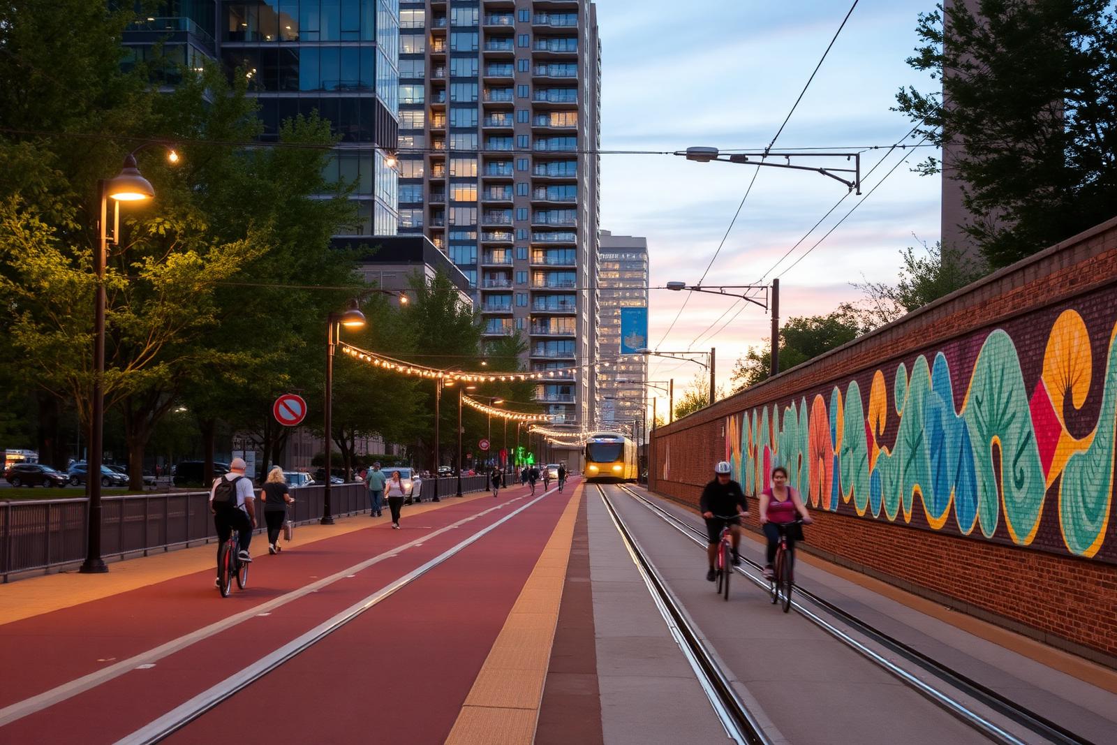
The Charlotte Rail Trail at dusk with cyclists, murals, and apartment towers above

Trail & Public Art

The Charlotte Rail Trail Through South End

The Rail Trail runs alongside the LYNX Blue Line tracks, stitching together South End's breweries, apartment towers, and old mill blocks into a single walkable spine. It has done as much to define the district's identity as any building along it.

~3 mi

trail length through South End

4

LYNX stations along the corridor

Dozens

public art installations

Mixed-use

development fronting the path

A Spine Built on Old Rail Right-of-Way

The Rail Trail occupies the corridor beside the light rail tracks that once carried freight and, before that, the Southern Railway lines that gave South End its industrial start. Rather than hide the infrastructure, the trail's designers ran the pedestrian and bike path directly alongside the rails, so riders on the Blue Line and walkers on the trail share the same visual corridor through the district.

That decision shaped how South End developed above ground. Property owners along the corridor oriented patios, storefronts, and lobby entrances toward the trail rather than away from it, treating what could have been a utilitarian rail buffer as the district's front door instead.

The result is a linear public space that functions less like a conventional greenway and more like a Main Street without cars — one that happens to run for roughly three miles through the heart of South End.

Reading the Trail North to South

Starting near Uptown's edge, the trail passes through the Design District's converted warehouses before reaching the stretch near Atherton Mill, where the corridor widens into plazas used for markets and outdoor seating. This northern section tends to be the busiest, with the highest concentration of restaurants and breweries backing directly onto the path.

Moving south past the Bland Street area, the trail threads between newer apartment towers and older single-story commercial buildings that haven't yet been redeveloped, offering a visible contrast between South End's past and its current building cycle.

By the time the trail approaches the East-West Boulevard and Scaleybark station areas, the density thins out and the corridor takes on a quieter, more residential character, bordering Wilmore and Sedgefield rather than the commercial core.

Public Art as Wayfinding

The trail is lined with murals, sculpture, and installed artwork that doubles as informal wayfinding — regular riders and residents often describe locations along the trail by the nearest mural or sculpture rather than by street address.

Much of the art reflects the district's textile and rail history: pieces referencing bobbins, looms, and freight cars appear at several points along the corridor, a deliberate nod to the mills that once lined these same tracks.

The artwork rotates and is added to periodically, funded through a mix of public and private investment tied to the redevelopment happening on adjacent parcels, which means the trail's visual character shifts gradually as new buildings go up around it.

Access Points and Connections

The trail connects directly to each of South End's LYNX stations, making it easy to combine a light rail trip with a walk or bike ride to a final destination rather than driving the last half-mile.

Cross streets including West Boulevard, Tremont Avenue, and Camden Road intersect the trail at grade, and most of these crossings are signalized or marked, though cyclists and pedestrians should still expect to yield to turning traffic at the busier intersections.

Bike racks and, in a few locations, bike-share docks sit near the busiest crossings, reflecting how much of the trail's ridership arrives on two wheels rather than on foot.

  • Direct access from Carson, Bland Street, New Bern, and East-West Boulevard stations
  • At-grade crossings at West Boulevard, Tremont Avenue, and Camden Road
  • Bike racks clustered near major intersections and station platforms

How the Trail Shaped Development Patterns

Once the trail's route was set, land values along it rose faster than parcels a block or two away, and developers began favoring sites with direct trail frontage for both residential and retail projects.

This pattern accelerated adaptive reuse of the district's old mill and warehouse buildings, since many of those structures happened to sit along the original rail corridor and gained new value once the trail made them pedestrian-accessible rather than isolated behind fencing and loading docks.

Planners and Charlotte Center City Partners have both pointed to the trail as a template for how a piece of transportation infrastructure can double as a public amenity that pulls private investment toward it rather than away.

Using the Trail Day to Day

On weekday mornings and evenings, the trail carries a steady stream of commuters walking or biking to and from the light rail stations, mixed with residents out for exercise.

Weekends bring a different crowd — families, dog walkers, and groups moving between breweries and restaurants — and the busiest stretch near Atherton Mill can feel closer to a plaza than a trail during Saturday afternoons.

Because the trail is unshaded in several sections, particularly further south, regular users tend to adjust timing seasonally, favoring early morning or evening trips during Charlotte's hotter months.

At a glance

What matters most here

Atherton Mill Plaza

The widened plaza section near Atherton Mill is the trail's social hub, ringed by restaurants and market space.

Station Connections

Every South End LYNX station has a direct trail tie-in, making rail-to-trail trips seamless.

Mural Corridor

Textile- and rail-themed public art appears at intervals along the full length of the trail.

Orientation

Where this sits in South End

Everything in the district is measured against the Blue Line and the Rail Trail. Use the map to place the blocks referenced above.

N ↑Morehead StEast/West BlvdTremont AveUptown CharlotteCarson StationBland Street StationEast/West Blvd StationNew Bern StationCharlotte Rail TrailAtherton MillDesign DistrictBrewery RowWilmoreDilworthSedgefieldLoSoLowe's Tech Hub

Interactive map

Hover or tap a marker

The Blue Line runs the length of South End on a northeast–southwest diagonal, with the Rail Trail beside it. Nearly everything in the district is measured by how far it sits from that spine.

  • Blue Line station
  • Landmark
  • Sub-district
  • Employer / anchor

Answered

Questions & Answers

How long is the Charlotte Rail Trail through South End?

The trail runs roughly three miles through South End, paralleling the LYNX Blue Line tracks from near Uptown down toward Sedgefield and Wilmore.

Source: Charlotte Area Transit System — LYNX Blue Line

Can you bike the entire Rail Trail?

Yes, the trail is designed for both pedestrians and cyclists, with a paved surface running its full length and marked crossings at major intersections.

Source: Charlotte Rail Trail — Charlotte Center City Partners

Does the trail connect to the light rail stations?

It does — the trail runs directly alongside the tracks and links to each of South End's LYNX stations, making combined rail-and-trail trips common.

Source: Charlotte Area Transit System — LYNX Blue Line

Is the trail well-lit at night?

Sections near the district's commercial core are lit and busy after dark, but some stretches further from Atherton Mill are quieter and less consistently lit.

Source: Charlotte-Mecklenburg Historic Landmarks Commission

Who maintains the Rail Trail?

Maintenance involves a mix of city agencies and the district's public-private partnerships, reflecting the trail's origin as both transportation and public-realm infrastructure.

Source: Charlotte Rail Trail — Charlotte Center City Partners

Why does the trail have so much public art?

The art program grew alongside redevelopment along the corridor, funded in part by adjacent private projects and intended to reference the district's rail and textile history.

Source: Charlotte-Mecklenburg Historic Landmarks Commission

Primary Sources

Figures are compiled from public records and primary sources and are reviewed periodically. Conditions in South End change quickly — verify anything you intend to rely on.